ID 707090 | MPN 215
National Geographic
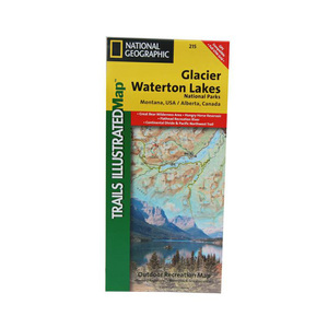
National Geographic Glacier Waterton Lakes National Parks Trail Map Montana


Save up to $50 on your online order today!
Advertised prices may display a strikethrough or regular price. The strikethrough or regular price represents either 1) the manufacturer’s Minimum Advertised Price (MAP) OR the Manufacturer’s Suggested Retail Price (MSRP) or 2) a price at which the product was offered within the last 90 days.
707090

National Geographic Glacier Waterton Lakes National Parks Trail Map Montana
by National Geographic
$14.95
Overview
National Geographic Glacier Waterton Lakes National Parks Trail Map Montana - Waterton Lakes NP includes Waterton Park, Upper and Middle Waterton Lakes, The Border Ranges, Akamina Kishinena Provincial Park, Blood Timber Reserve, and more. Glacier National Park covers the entire national park area, with detailed trails, and topographic information. Includes the Lewis and Clark Range, Many Glacier, Lake McDonald, Great Bear Wilderness, Flathead National Forest, Columbia Falls, Horse Reservoir, St. Mary Lake, and much more. UTM grids for use with your GPS unit are also provided.
- Folded Size: 4.25"x9.25"
- Fully Open Size: 25.5"x37.75"
- Scale: 1:100,000
- Map Revised: 2004
Specifications
| Model | 215 |
|---|
Reviews
Notify Me When In Stock
You are tracking this product.
You have removed this product alert
Thank You,
An error occurred processing your request. Please try again later.
Please enter a valid email


CUSTOMER GALLERY