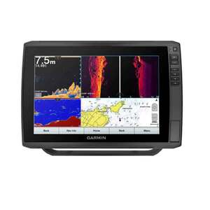
Garmin ECHOMAP Ultra 126sv Fish Finder with GT56 Transducer, g3
$2,299.97

$2,299.97
Overview
The Garmin ECHOMAP Ultra Fish Finder
Sunlight-readable touchscreen combo features may include
- Keyed-assisted touchscreen puts fishfinding know-how at your fingertips.
- Crisp images of structure and fish in stunning detail.
- Explore your new favorite spot; create maps on the fly, and tailor them to fit your needs.
- QUICKDRAW CONTOURS - Create personalized fishing maps on-screen with 1’ contours. Keep the data to yourself, or share it with the Garmin Quickdraw Community on the Garmin Connect app (Requires app on your compatible smartphone).
- NETWORK CAPABLE - Connect your boat to share data, sonar and charts with your other compatible devices.
- NMEA 2000 NETWORK COMPATIBILITY - Connect to your compatible autopilots, digital switching, weather, Fusion-Link™ audio system, media, VHF, AIS, engine data, heading sensors — such as the SteadyCast™ sensor — and more from one screen.
- ACTIVECAPTAIN APP - Built-in Wi-Fi connectivity pairs with the free all-in-one mobile app for access to the OneChart feature, smart notifications, software updates, Garmin Quickdraw Community data and more (Requires the ActiveCaptain app on your compatible smartphone paired to the ECHOMAP Ultra)
- FORCE TROLLING MOTOR COMPATIBILITY - Take control of the most powerful and efficient trolling motor available (in compliance with ISO standard 13342), route it to waypoints, follow tracks and more from the screen of your Fish Finder.
- QUICK DISCONNECT - Keep your ECHOMAP Ultra safe and secure. Cords plug directly into the quick-disconnect bail mount, which allows you to quickly install and remove your unit.
- ENGINE CONNECTIVITY - Connect this chartplotter to different kinds of engines — including select Mercury and Yamaha models — to see RPMs, fuel flow, temperature, trim and other important information at a glance. You may need additional hardware, so be sure to check with your engine manufacturer.
Transducer Features:
- VIVID COLOR PALETTES
High-contrast vivid scanning sonar color palettes make it easier than ever to distinguish targets and structure.
- ULTRA HIGH-DEFINITION (UHD) SONAR
CHIRP traditional sonar and Ultra High-Definition ClearVu and SideVu scanning sonars. With three scanning sonar frequencies and 20% greater range for our UHD SideVu sonar, you’ll get top performance at all depths.
- LIVESCOPE SONAR SUPPORT
LiveScope sonar allows you to see below the water with stunning real-time imagery. The view is so clear, you can see structure, schools of fish and even watch how fish react to your bait. With image stabilization, vivid colors, a customizable view and 3 directional modes.
Forward Mode - Scout ahead of your boat to see what’s happening in real time.
ClearVu (Down Mode) - Explore live views of the activity directly beneath your boat.
Perspective Mode - See under the water with a view from your perspective above the water.
You can find the fish — wherever they are.
g3 BLUECHART AND LAKEVU PRELOADED CARTOGRAPHY CHARTS
Fish Finders not compatible with the newer Garmin Navionics+ will still enjoy unparalleled coverage and detail with BlueChart g3 coastal charts for the U.S. and Western Canada and LakeVu g3 inland maps for the U.S. Check compatibility.
NAVIONICS+
- Automatic Routing Technology – Combining Auto Routing with Auto Guidance+ gives boaters a suggested dock-to-dock path to follow through channels, inlets, marina entrances and more. Desired depth, overhead clearance, frequently traveled routes. Also, continually references shoreline, depths, POIs, buoys and obstacle locations. Users can easily identify the level of risk associated with their suggested pathways, be aware of nearby hazards and adjust their saved routes by adding multiple waypoints on their screens. (for planning purposes only does not replace save navigation operation
- Map Data with Daily updates - Daily updates available via the ActiveCaptain smart-device app. As you know, water bodies and coastline features are constantly moving and changing. To keep our Garmin Navionics+ and Garmin Navionics Vision+™ mapping current, we make up to 5,000 updates every day — using public and private data sources, proprietary surveys, notices to mariners and data reported by users. Updates include improved bathymetry, the repositioning, addition or removal of navigational aids and other objects, coastline updates with the inclusion of new marinas or jetties and much more.
Specifications
| Bluetooth Compatible | Yes |
|---|---|
| Charts and Maps | Garmin g3 BlueChart(Costal), LakeVu(Inland), Tide Tables |
| Depth Capacity | 2,300 ft. (701 m) at 77 kHz |
| Display Resolution | WXGA, 1280 x 800 pixels |
| Display Size | 12in |
| Frequency | TRADITIONAL SONAR (DUAL BEAM) - single channel CHIRP, 70/83/200 kHz, L, M, H CHIRP, CLEARVU - 260/455/800/1000/1200 kHz, SIDEVU - 260/455/800/1000/1200 kHz |
| GPS | Yes |
| Model | 010-02529-01 |
| Power Output | 600 W |
| Series | ECHOMAP Ultra |
| Sonar Type | CHIRP SideVu, ClearVu (Side,Down Imaging), LIVESCOPE, Panoptix 3D |
| Touchscreen | Yes |
| Transducer | GT56UHD-TM |
| Type | Fish Finder |


CUSTOMER GALLERY