ID 701109 | MPN 701
National Geographic
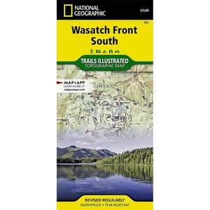
National Geographic Wasatch Front South Trail Map Utah


Save up to $50 on your online order today!
Advertised prices may display a strikethrough or regular price. The strikethrough or regular price represents either 1) the manufacturer’s Minimum Advertised Price (MAP) OR the Manufacturer’s Suggested Retail Price (MSRP) or 2) a price at which the product was offered within the last 90 days.
701109

National Geographic Wasatch Front South Trail Map Utah
by National Geographic
$4.92
Overview
National Geographic Uinta National Forest Trail Map Utah - National Geographic's Trails Illustrated map of Wasatch Front South is the most comprehensive guide for outdoor enthusiasts enjoying the year-round recreation activities in this region. Expertly researched and created in cooperation with the U.S. Forest Service and others, this map features key points of interest from Goshen and Juab Valleys in the west to Strawberry Ridge and Wasatch Plateau in the east. Coverage includes recreation hotspots Uinta and Manti-La Sal National Forests, Mt. Nebo Wilderness Area, San Pitch Mountains, Joes Valley Reservoir and Lake Canyon Recreation Area.
- Folded Size: 4.25in x 9.25in
- Fully Open Size: 25.5in x 37.75in
- Scale: 1:75,000
- Map Revised: 2020
Specifications
| Type | Map |
|---|---|
| Model | 701 |
Reviews
Notify Me When In Stock
You are tracking this product.
You have removed this product alert
Thank You,
An error occurred processing your request. Please try again later.
Please enter a valid email


CUSTOMER GALLERY